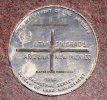
The only place in the United States where four state boundaries come together was first surveyed by the U.S. government in 1868 during the initial survey of Colorado's southern boundary line.
The intended location was 109 degrees west longitude and 37 degrees north latitude. But, because of surveying errors, the popular tourist spot is actually just a bit off.
"That's a long ways to be off," said David Bronson, surveyor of San Juan County, Utah. Still, he said the monument's present location is the accepted one.
Bronson said that given the crude equipment of the era, it's amazing surveyors were as accurate as they were around the time the marker was established.


")