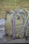
Distance keeping with beads?

Nic Ramirez

Gold Member
Joined
Apr 17, 2003
Messages
1,889
I've always wondered how you military fellas keep track of distance with beads. You hear them say "It's 20 clicks away." What the hell is a click? I’m guessing military jargon for an increment of distance close to a kilometer.

Seems like a good way to keep track, nothing to break.

Check out the pic and you can see what I'm talking about. Anyone have any informative links to accurately demonstrate this method?
 

Attachments

  • 02-usrsog7.jpg
    02-usrsog7.jpg
    47.2 KB · Views: 246
Most maps and aerial photos in the U.S. are designed around 1" = 1320' or divisible there by. 1,320' is a 1/4 of a mile, a mile being 5,280'. For most in the Natural Resouces fields, chains is the unit of measure. A chain is 66' and there are 80 chains in a mile. This corresponds well with most compasses as they have a 1/20th scale on the side. For those that get in orienteering, I suggest learning this method of counting chains. For most people, 12 paces = a chain. So if someone said go 5 chains at 180, that means go 330' due south.

Another way chains fits into our english system is an acre is 10 chains by 1 chain. An acre being 43,560 sq. ft.

Just an FYI. Sorry to ramble.
 
Hey Nic!
Well, not having served... all's I know is the klik is short for kilometer, and that if you count so many paces and move one of the beads, you will be able to relatively accurately judge distance traveled... No, I've never done it, but several catalogs offer the bead systems and some of them offer tips on use... Try Brigade Quartermasters for one, they have some good info in their catalogs, too... You'll also find some helpful hints on usage if you can find stuff out about orienteering - they can come in real handy for that!
 
Nic, they are easy to use if you remember to count. It is a great way to know your distance traveled. 100 meters, move a lower bead up or down. Keep going till you get 9 up or down, and then move an upper bead. Then start all over again going the opposite way you started.

I used them for a few years, and still have some on my pack.

I hope I did not make things more complicated but they are a valuable inexpensive tool.
 
Interesting links -- I was just thinking about these the other day and thought it would be nice to have a lanyard of a neck knife with a pace-counter. (easy to reach, as long the blade is taunt enough not to pull out when you move a bead. ;) )

Time to hit the shop!
 
I was in the Canadian Forces, and never ran into pace beads 'til I joined the Airborne Regiment. There we used a leather shoe lace with a knot in it and rubber washers threaded onto it. five on the short side and nine on the long side. You just figure out how many left foot falls (full paces) it takes you to go 100 metres. Do this on a variety of terrain and average it, but you need to know how many for steep up and down hill as well. After 100 M. slide one of the 9 washers away from the middle ( if you attach the centre knot to a pocket button it works better) after the ninth washer, go another 100 M. pull one of the five down, and slide up the nine. This system will let you measure 6
Km.
 
I use these on my Becker Necker, I also make and sell them at gun shows. They definately come in handy provided you know your pace count per 100 meters.
 
Yeah, I'm getting a batch together for a gunshow at the end of this month. I'll try to get pics.
 
Leave it to a Canadian to clarify the use of pace beads!!! LOL!!! Thanks Mooseman, as that was clearer than how I understood it till now! :D
 
Oh sure, take the easy route and use Ranger Beads. Us truley cheap bubbas just pick up a pebble every 100 meters as we're trekking along.
Just kidding, A lot of use use 'em or make up our own system.
 
That's a nice link Steven!

Brought back some memories of dismounted land nav while I was in the Army many moons ago.

What you need to do to figure out pace count is to measure out 100 meters, count how many times your left foot hits the ground one way, count again coming back, and average the two. In my case (5'10") it takes me 69 paces for 100 meters.

Going uphill, your count gets bigger since you take shorter steps. Downhill, your count gets smaller since you take longer strides.

If possible, set up an uphill and downhill practice lane. This is really guesstimation however because the steepness of the terrain differs and so will your pace count. That is why it helps to have a map. You can compare the contour lines to your progress.

Practice, practice, practice!

I just picked up a set of skull pace count beads from CSM Tactical Gear under the accessories section.

The beads cost $3.00 USD and with tax and shipping (I live in CA) it was still under $4.00.

Some troops complained that the skull beads are too fragile, but I've had these for a month without any problems. They may have got theirs from USCavalry since CSMGear just started listing these a little over a month ago.

I have them on my keyring (with lots of keys, an Arc AAA, UtiliKey, and a small whistle from REI) so it gets banged around alot along with any change in my pocket. It has still held up without any problems.

I loop it next to the house key so when I pull them out, my keys are indexed pretty quickly and I don't have to go fumbling around.
 
To use these effectively you really have to know your accurate pace measure per 100 meters and how it changes. You pace shortens going uphill or down and also shortens if you are carrying a pack and how much. It will be different for different terrain and trail types. It is very accurate on roads and nearly impossible to do in heavy brush.

I made recently made up two sets of beads, one with rubber washers and the other with wooden craft beads. They are easy to make, nine on the lower part and five on
the upper. The lowers mark in 100 meter increments and the upper mark the kilometers. The average man wil step about 66 paces to 100 meters. After 66 paces you pull a lower bead. After the ninth bead you pull an upper bead to mark the "Click".
It sounds simple in theory but you really have ot know your paces and how your load and grade are affecting your pace.

Whenever you can locate yourself on the map by some sure terrain feature you start the count at zero again. The longer you go without starting over the less accurate your measure will be. It can really be a help in the short run if you are negotiating around a terrain feature and want to pick up the old azimuth again. Mac
 
Back
Top