- Joined
- Apr 1, 2009
- Messages
- 1,079
Hey Guys,
I got out to the Catskills last weekend with my son, and my two buddies, Wood Trekker (who has a great outdoors blog) and Mibuwulf.
My camera crapped out and my i-phone pics weren't great, so Wood Trekker has allowed my to re-post his trip report here for you guys. You can check out his blog at http://woodtrekker.blogspot.com/
While this wasn't a multi-day trip, didn't have eye-popping views, and wasn't the longest or steepest, this outing was one of the most rewarding, trips I've ever done.
From orienteering through the dense, fog shrouded forest, to viewing pieces of history only a few people will ever see, to literally clawing our way up unstable pitches, to dealing with some of the most ankle twisting terrain imaginable, to making a fire in soaking wet conditions, to surviving a lightning storm that was way too close for comfort, to dealing with surprisingly cold temperatures and finally making our way out along a river that was like an obstacle course of downed trees, river crossings and piles of rocks and boulders--- This trip was an epic adventure!
Thanks to all involved and especially Wood Trekker for planning this, navigating, taking pictures for everyone and doing the fantastic write up from his blog that follows.:thumbup:
Trip Report: Van Wyck Mtn Airplane Crash Sites:
A few months back I did a three day trip where I bushwhacked to an airplane crash site next to Friday Mountain in the Catskills. You can see that trip report here in Part 1 (http://woodtrekker.blogspot.com/2012/08/trip-report-airplane-crash-site-8312.html) and Part 2 (http://woodtrekker.blogspot.com/2012/08/trip-report-airplane-crash-site-8312_10.html).
Well, the report of the trip inspired some of my friends from Blades and Bushcraft (Beanbag, Son O', and Mibuwolf) to do a similar trip. We did some searching around and discovered that on Van Wyck Mountain, also in the Catskills, there were two separate airplane crash sites. On top of that, they were not nearly as remote as the one on Friday Mountain, and could be reached without having to go into the spruce cap where bushwhacking becomes a nightmare. We figured it could be done as an overnight trip. We would be bushwhacking the whole way without catching any trails. Here was the plan:

We would start at the parking lot on Peekamoose Road, marked as (P) on the map. From there we would take a bearing and go up to the firts airplane crash site, marked as (1). From that site we would take a bearing to the second crash site (2) and follow it there. Then it would be a climb to the top of Van Wyck Mountain. At that point we would descent down the east side of the mountain until we reach the saddle between the two peaks. We planned on camping somewhere in that location. The following day we would go down until we reach Bear Hole Brook, and we would follow it out to the road and parking lot. If you are wondering, the reason why we didn't want to try going directly from Van Wyck Mountain to Bear Hole Brook is that the side of the mountain at that location looked to be extremely steep.
The trip seemed doomed from the beginning. Here is what the weather forecast looked like on the day before we set out:

That is, rain with severe thunderstorms on Saturday, and rain with the temperatures going down into the 30s (F) on Sunday. But, we all manned up, pulled out our rain gear and arrived at the parking lot at 9AM as agreed.
We quickly encountered our first obstacle. In our way was a small river, that none of us had paid much attention to. We all managed to make it about half way through by rock hopping, before we realized that there was no easy way to the other side. We decided to take off our shoes and go straight through. It appears that Beanbag decided that was too uneventful, and figured he would throw one of his shows across to the other bank of the river before taking off the other one. Predictably, the shoe landed in the river, but miraculously stayed floating upright long enough for Mebuwolf to run in and get it. After that, everyone managed to cross without a problem.

The initial part of the trip was steep, and slow going. We had to stop often to catch our breath and get water.

There wasn't much time to look around for the wildlife, but during some of the stops, I was able to take a few pictures.


We were lucky in that the rain held out. However, everything was soaked, and the sky remained overcast. Once we started gaining elevation, we entered a thick layer of fog, which made everything dripping with condensation. While it was not technically raining, we felt like we were walking through water.

We kept to our bearing, continuing the climb. At one point I started to suspect that we were drifting a bit to the left of our bearing due to the terrain. It was easier to notice from the back of the line where I was at that point. So, when we reached the elevation where we expected the airplane to be (elevation courtesy of Beanbag's phone), we split up and did a canvas search of the area to our right. Not far from where we were, we saw the airplane wreckage.


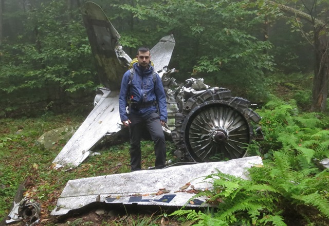
It looked to be a an old 60's jet plane. Son O' was able to identify the model, but I don't remember what it was. We were very lucky to find it, because we were indeed off of our bearing, and we made a lucky guess where to stop climbing and canvas the area. We thought this would be a good time for a group picture.

When we were finished looking around the plane, we decided to get lunch, as it was about noon. After lunch we took a bearing towards the second airplane crash site and got on our way. The fog continued to limit our visibility and cover everything is moisture.

The big plus side was that the terrain had more or less leveled out, making the trek a lot more pleasant. I was able to snap a few pictures of interesting plants.


This time we stuck close to our bearing, and before long we ran right into the second airplane crash site.


The debris of this airplane was scattered over a very large area. There were pieces everywhere, and what was left was heavily damaged. In the above pictures you can see pieces of the engine block which had fallen apart. We got some rest at the site. I had a quick snack.

From here all that was left to do was the last uphill section of the trip, up to Van Wyck Mountain. For a while, the elevation change was very gradual. Again, I couldn't help myself and I had to take pictures of random things.


Soon however the elevation started to change quickly. While not the steepest slopes that I have ever climbed, the fact that it had been raining, and everything was wet, made it extremely difficult to climb. The soil kept sliding out from under our feet. We had to do a lot of scrambling to make it up the mountain.


Eventually we made it to the top of Van Wyck Mountain. It wasn't a particularly exciting place. Between the fog and the heavy tree cover, there wasn't much to see. Besides, it was getting to be close to 5PM, and with sunset less that two hours away, we had to make our way don't the mountain in search of a suitable place to set up camp. We descended down the eastern slope, leaving the mountain behind us in the fog.

Looking at the above picture now, that cliff kind of looks like a human face. It's not something I noticed when taking the picture.
We followed the terrain down until we reached the saddle. The whole time we searched for a good camp location, but could not find anything. Everything was covered in rocks and holes. Eventually, we decided to split up and find individual locations where we could set up. We picked a central spot where we made a fire despite the wet weather, courtesy of some fat wood brought by Beanbag and some birch bark that Mebuwolf had collected along the way.

I managed to clear out a large enough area to set up my GoLite Shangri-La 3. I had switched to the smaller shelter exactly for reasons such as this one. All that was left to see if if the performance would be good enough.

After setting up camp, we ate dinner by the fire. Just as the sun set, the fog cleared, and was replaced by the thunderstorm that we were awaiting. I grabbed my things and headed back to my tent. It was not easy to find in the dark, even with my flashlight. Eventually, I got in, took off my wet clothing, jumped in my sleeping bag. I don't know if you can see anything from this picture, but it was really coming down.

Soon we started getting some lightning. The first one was so close, I was sure it landed in our camp site. Mibuwolf who was watching the storm from his hammock, and gathering the rainwater from his tarp, saw the lightning hit a few dozen feet from where Beanbag's tent was set up. The rain continued on and off through the night, but was over by the time we got up in the morning. The temperatures dropped into the 30s (F). By the time we got up, they were in the low 40s (F). I had to sleep with both my fleece shirts on in order to stay warm.
The GoLite Shangri-La 3 held up well during the storm. However, I did have a problem. There was a fair amount of condensation on the inside of the tent. I get the same thing with the Shangri-La 5, but with the Shangri-La 3, the footprint is small enough that during the night, the sleeping bag by my feet, touched the wall of the tent. It then ended up absorbing a lot of the condensation, getting it wet. This could end up being a real problem.
I got out to the Catskills last weekend with my son, and my two buddies, Wood Trekker (who has a great outdoors blog) and Mibuwulf.
My camera crapped out and my i-phone pics weren't great, so Wood Trekker has allowed my to re-post his trip report here for you guys. You can check out his blog at http://woodtrekker.blogspot.com/
While this wasn't a multi-day trip, didn't have eye-popping views, and wasn't the longest or steepest, this outing was one of the most rewarding, trips I've ever done.
From orienteering through the dense, fog shrouded forest, to viewing pieces of history only a few people will ever see, to literally clawing our way up unstable pitches, to dealing with some of the most ankle twisting terrain imaginable, to making a fire in soaking wet conditions, to surviving a lightning storm that was way too close for comfort, to dealing with surprisingly cold temperatures and finally making our way out along a river that was like an obstacle course of downed trees, river crossings and piles of rocks and boulders--- This trip was an epic adventure!
Thanks to all involved and especially Wood Trekker for planning this, navigating, taking pictures for everyone and doing the fantastic write up from his blog that follows.:thumbup:
Trip Report: Van Wyck Mtn Airplane Crash Sites:
A few months back I did a three day trip where I bushwhacked to an airplane crash site next to Friday Mountain in the Catskills. You can see that trip report here in Part 1 (http://woodtrekker.blogspot.com/2012/08/trip-report-airplane-crash-site-8312.html) and Part 2 (http://woodtrekker.blogspot.com/2012/08/trip-report-airplane-crash-site-8312_10.html).
Well, the report of the trip inspired some of my friends from Blades and Bushcraft (Beanbag, Son O', and Mibuwolf) to do a similar trip. We did some searching around and discovered that on Van Wyck Mountain, also in the Catskills, there were two separate airplane crash sites. On top of that, they were not nearly as remote as the one on Friday Mountain, and could be reached without having to go into the spruce cap where bushwhacking becomes a nightmare. We figured it could be done as an overnight trip. We would be bushwhacking the whole way without catching any trails. Here was the plan:
We would start at the parking lot on Peekamoose Road, marked as (P) on the map. From there we would take a bearing and go up to the firts airplane crash site, marked as (1). From that site we would take a bearing to the second crash site (2) and follow it there. Then it would be a climb to the top of Van Wyck Mountain. At that point we would descent down the east side of the mountain until we reach the saddle between the two peaks. We planned on camping somewhere in that location. The following day we would go down until we reach Bear Hole Brook, and we would follow it out to the road and parking lot. If you are wondering, the reason why we didn't want to try going directly from Van Wyck Mountain to Bear Hole Brook is that the side of the mountain at that location looked to be extremely steep.
The trip seemed doomed from the beginning. Here is what the weather forecast looked like on the day before we set out:
That is, rain with severe thunderstorms on Saturday, and rain with the temperatures going down into the 30s (F) on Sunday. But, we all manned up, pulled out our rain gear and arrived at the parking lot at 9AM as agreed.
We quickly encountered our first obstacle. In our way was a small river, that none of us had paid much attention to. We all managed to make it about half way through by rock hopping, before we realized that there was no easy way to the other side. We decided to take off our shoes and go straight through. It appears that Beanbag decided that was too uneventful, and figured he would throw one of his shows across to the other bank of the river before taking off the other one. Predictably, the shoe landed in the river, but miraculously stayed floating upright long enough for Mebuwolf to run in and get it. After that, everyone managed to cross without a problem.
The initial part of the trip was steep, and slow going. We had to stop often to catch our breath and get water.
There wasn't much time to look around for the wildlife, but during some of the stops, I was able to take a few pictures.
We were lucky in that the rain held out. However, everything was soaked, and the sky remained overcast. Once we started gaining elevation, we entered a thick layer of fog, which made everything dripping with condensation. While it was not technically raining, we felt like we were walking through water.
We kept to our bearing, continuing the climb. At one point I started to suspect that we were drifting a bit to the left of our bearing due to the terrain. It was easier to notice from the back of the line where I was at that point. So, when we reached the elevation where we expected the airplane to be (elevation courtesy of Beanbag's phone), we split up and did a canvas search of the area to our right. Not far from where we were, we saw the airplane wreckage.
It looked to be a an old 60's jet plane. Son O' was able to identify the model, but I don't remember what it was. We were very lucky to find it, because we were indeed off of our bearing, and we made a lucky guess where to stop climbing and canvas the area. We thought this would be a good time for a group picture.
When we were finished looking around the plane, we decided to get lunch, as it was about noon. After lunch we took a bearing towards the second airplane crash site and got on our way. The fog continued to limit our visibility and cover everything is moisture.
The big plus side was that the terrain had more or less leveled out, making the trek a lot more pleasant. I was able to snap a few pictures of interesting plants.
This time we stuck close to our bearing, and before long we ran right into the second airplane crash site.
The debris of this airplane was scattered over a very large area. There were pieces everywhere, and what was left was heavily damaged. In the above pictures you can see pieces of the engine block which had fallen apart. We got some rest at the site. I had a quick snack.
From here all that was left to do was the last uphill section of the trip, up to Van Wyck Mountain. For a while, the elevation change was very gradual. Again, I couldn't help myself and I had to take pictures of random things.
Soon however the elevation started to change quickly. While not the steepest slopes that I have ever climbed, the fact that it had been raining, and everything was wet, made it extremely difficult to climb. The soil kept sliding out from under our feet. We had to do a lot of scrambling to make it up the mountain.
Eventually we made it to the top of Van Wyck Mountain. It wasn't a particularly exciting place. Between the fog and the heavy tree cover, there wasn't much to see. Besides, it was getting to be close to 5PM, and with sunset less that two hours away, we had to make our way don't the mountain in search of a suitable place to set up camp. We descended down the eastern slope, leaving the mountain behind us in the fog.
Looking at the above picture now, that cliff kind of looks like a human face. It's not something I noticed when taking the picture.
We followed the terrain down until we reached the saddle. The whole time we searched for a good camp location, but could not find anything. Everything was covered in rocks and holes. Eventually, we decided to split up and find individual locations where we could set up. We picked a central spot where we made a fire despite the wet weather, courtesy of some fat wood brought by Beanbag and some birch bark that Mebuwolf had collected along the way.
I managed to clear out a large enough area to set up my GoLite Shangri-La 3. I had switched to the smaller shelter exactly for reasons such as this one. All that was left to see if if the performance would be good enough.
After setting up camp, we ate dinner by the fire. Just as the sun set, the fog cleared, and was replaced by the thunderstorm that we were awaiting. I grabbed my things and headed back to my tent. It was not easy to find in the dark, even with my flashlight. Eventually, I got in, took off my wet clothing, jumped in my sleeping bag. I don't know if you can see anything from this picture, but it was really coming down.
Soon we started getting some lightning. The first one was so close, I was sure it landed in our camp site. Mibuwolf who was watching the storm from his hammock, and gathering the rainwater from his tarp, saw the lightning hit a few dozen feet from where Beanbag's tent was set up. The rain continued on and off through the night, but was over by the time we got up in the morning. The temperatures dropped into the 30s (F). By the time we got up, they were in the low 40s (F). I had to sleep with both my fleece shirts on in order to stay warm.
The GoLite Shangri-La 3 held up well during the storm. However, I did have a problem. There was a fair amount of condensation on the inside of the tent. I get the same thing with the Shangri-La 5, but with the Shangri-La 3, the footprint is small enough that during the night, the sleeping bag by my feet, touched the wall of the tent. It then ended up absorbing a lot of the condensation, getting it wet. This could end up being a real problem.
Last edited:


