Excellent post..
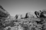
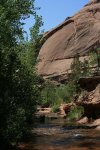
Negro Bill Canyon was named after William Granstaff, a black prospector and rancher who grazed his cattle here during the late 1800s. It is a lovely canyon, cut into the Navajo Sandstone by a small, perennial stream that begins about six miles from the southern shore of the Colorado River. The trail winds along the stream through an oasis of cottonwood and willow trees, cut off from the desert above by towering sandstone cliffs. Like all good hikes, this one also has a reward at the end. Morning Glory Natural Bridge spans the head of one of Negro Bills side canyons at the end of the trail. According to Bureau of Land Management statistics, Morning Glory is the sixth largest natural bridge in the United States. Its span is 243 feet.
In 1979 Negro Bill Canyon gained a great deal of notoriety over an action of the so called Sagebrush Rebellion. The Bureau of Land Management, wanting to study the canyon as a possible wilderness area, placed a barrier at its entrance to keep out recreational vehicles. This infuriated a group of local anti-wilderness activists who, with the help of the Grand County commissioners, bulldozed down the barrier. The county commissioners then publicly declared that the county, not the federal government, owned the canyon, and when another barrier was erected it was again bulldozed down. The conflict was resolved only after a lawsuit was filed against Grand County in the U.S. district court.
Today the canyon is still a wilderness study area, and may soon become the Negro Bill Wilderness Area. Many residents of Grand County are still against the idea, but fortunately tempers are no longer as hot as they once were. Four-wheel-drive vehicles are not now using the canyon and, although there are still some visible signs of the old jeep roads, most of the mess has now been cleaned up. With each passing year the old, unsightly scars are becoming less noticeable.
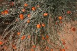
From the mouth of Negro Bill Canyon the trail begins by winding its way up the left side of the stream, then crosses the water four or five times. You may have to get your feet wet at some of the crossings, especially during the spring runoff. Wildlife is abundant along the canyon floor, and you can often see hawks soaring over the pink sandstone cliffs searching for prey. After 1.2 miles you will see a second large canyon intersecting Negro Bill on the right. Another less-used trail heads into this canyon, which you can follow if you feel like exploring. This is not the canyon containing Morning Glory Natural Bridge; however it does contain some nice campsites and picnic spots.
Continuing along the main trail for another 0.6 mile will bring you to the next major side canyon, again intersecting Negro Bill Canyon from the right. Here the path splits again, but this time the main trail turns right, into the side canyon, and proceeds southward toward Morning Glory Natural Bridge. The bridge is at the extreme end of the canyon, 0.4 mile from the junction.
Morning Glory Natural Bridge is unique because it was carved at the base of a waterfall, rather than across an open stream as most natural bridges are. The space between the bridge and the cliff over which the water once plunged is extremely narrow, only about 15 feet wide, but the span of the bridge is awesome. What a spectacle the waterfall behind the sandstone bridge must have been when the water was flowing in full force. Water seldom flows in the dry river bed now, but there is a small permanent spring near the base of the bridges eastern leg.


")
