-
The BladeForums.com 2024 Traditional Knife is available! Price is $250 ea (shipped within CONUS).
Order here: https://www.bladeforums.com/help/2024-traditional/
You are using an out of date browser. It may not display this or other websites correctly.
You should upgrade or use an alternative browser.
You should upgrade or use an alternative browser.
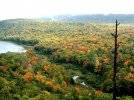
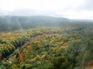
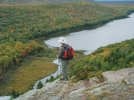
Porcupine Mountains State Park, UP, Michigan & south UP Waterfall
- Thread starter LMT66
- Start date
- Status
- Not open for further replies.
LMT66
Gold Member
- Joined
- Jun 18, 2008
- Messages
- 11,347
Before you go: Must have book before you go in the interior:
ISBN 0-9711654-4-0 Porcupine Mountains Companion - Inside Michigan's Largest State Park by Michael Rafferty and Robert Spraque, 4th Edition
and
A great book of short Bear Tales from his years as a Park Ranger. I can't stress how much a pleasure it is to read this book of bear stories thru this man's many years as a PM SP Ranger!
ISBN 978-0-9623664-6-4 True Bear Tales - By Ranger David E. Young, Porcupine Mountains Wilderness State Park -4th Edition
http://www.michigan.gov/documents/dnr/07porkies_backcountry-brochure__map_184899_7.pdf
Trail map to this 60,000 acre Midwest Gem.
Please note, all waterfalls were running low volume in late fall. Springtime is spectacular! Have some to show in a month or so.
Last edited:
- Joined
- Mar 22, 2006
- Messages
- 5,944
Beautiful, Bro! Very nice country
- Joined
- Jan 16, 2009
- Messages
- 5,679
Wow, that is a beautiful place. Very nice pictures. It looks like I have another summer trip to do.
- Joined
- Oct 24, 2005
- Messages
- 1,836
The "Porkies" were the first place I ever went backpacking and I have been back there several times. While it might not have the majesty of the Rockies or parts of the desert southwest (both of which I have backpacked, too) it is still a beautiful place and one I hope to return to one of these days.
- Joined
- Sep 2, 2004
- Messages
- 2,512
The Porcupine Mountains are awesome.


- Joined
- Sep 2, 2004
- Messages
- 2,512


mtnfolk mike
Gold Member
- Joined
- Mar 21, 2006
- Messages
- 10,040
wow.. that place is gorgeous...
- Joined
- Jan 12, 2006
- Messages
- 6,237
My wife and I and another couple drove up to the Porkies from Minnesota last fall for a week of camping and hiking. We timed it perfectly as the fall colors were in absolute peak. Unfortunately it rained non-stop the whole time we were there. We ended up just packing it in and heading back early. But the few hikes we did were nice.
Attachments
- Joined
- Dec 4, 2005
- Messages
- 955


Love these pictures! That's some amazing country.
What's the last picture? If it's seashore, it sure looks different that what we see on this side.
- Joined
- Oct 24, 2005
- Messages
- 1,836
That would be Lake Superior. People who have never seen them in person are often supprised at just how huge and sea-like the Great Lakes can be. Lake Superior itself is larger than the state of South Carolia, and waves of 20-30 feet are not uncommon during winter storms. Lake Supperior is also the site of the title event of the famous Gordon Lightfoot song "The Wreck of the Edmund Fitzgerald" about a 700+ foot freighter that went down during a November storm.What's the last picture? If it's seashore, it sure looks different that what we see on this side.
")

- Joined
- Jun 9, 2007
- Messages
- 6,347
That would be Lake Superior. People who have never seen them in person are often supprised at just how huge and sea-like the Great Lakes can be. Lake Superior itself is larger than the state of South Carolia, and waves of 20-30 feet are not uncommon during winter storms. Lake Supperior is also the site of the title event of the famous Gordon Lightfoot song "The Wreck of the Edmund Fitzgerald" about a 700+ foot freighter that went down during a November storm.
There is actually a fairly large and active Great Lakes surfing community.
Jeff
LMT66
Gold Member
- Joined
- Jun 18, 2008
- Messages
- 11,347
That would be Lake Superior. People who have never seen them in person are often supprised at just how huge and sea-like the Great Lakes can be. Lake Superior itself is larger than the state of South Carolia, and waves of 20-30 feet are not uncommon during winter storms. Lake Supperior is also the site of the title event of the famous Gordon Lightfoot song "The Wreck of the Edmund Fitzgerald" about a 700+ foot freighter that went down during a November storm.
Lake Superior gets very very rough! Being a massive shallow water basin, the wave heights get incredible. Enough to make any one with true "sea legs" shudder. I'm still looking for pictures I have of Lake Superior in full glory when I hiked the Lake Superior trail from the bluff over Lake in the Clouds to the Presque Isle scenic area. Will post if I find them.
All the photos everyone posted show a vast stand of timber. There are old abandoned copper mines thruout the park along with waterfalls, very rugged terrain. The road (unplowed in winter) that cuts thru the park is a 27 mile drive. It's a massive tract of land that looks no different today than it did 100 years ago. There are light day hikes on marked trails you can take with the family but you need to be cautious. This is a place you can pack into for a week and never see another soul. Well, humanwise anyway. There are ALOT of black bears and a small population of wolves along with certain cats. Bears being the biggest issue since careless campers have made them associate camper/hikers with a snack. If you go, bring bear spray (guns are not allowed in the park) and hang your food from provided bear poles or from a tree and use bear proof containers. There are cabins in the interior but no roads to them. If you pack into this park, be prepared because you are on your own and your cellphone wont work. Make sure you notify the rangers of your plans if camping. One note:
Along that 27 mile road thru the park, look for unofficial yellow markings placed on the road with arrows. These point in the direction of bear dens. Use caution in these areas especially this time of year.
Be prepared in summer for Bug Heaven!
- Status
- Not open for further replies.