For Hardcore Only

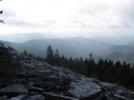
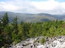
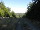
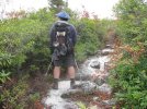
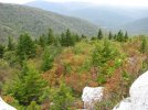
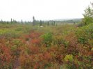
The Canyon Rim is pretty dry and you basically alternate between pushing thru the brush and spruce and scrambling over boulders.

crt1.jpg

crt2.jpg

crt3.jpg


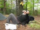
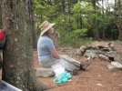
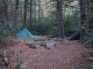
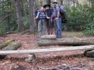
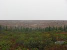
It was HOT Friday so we decided to camp at the Tipi Trail campsite so we'd be fresh Sat for "The Mother of all Talus Slopes"
 
getting pumped and relaxing at the same time before the next leg!!!!!

attachment.php


attachment.php


attachment.php


attachment.php


attachment.php


I had to take that last shot!!!!!
 

Attachments

  • IMG_2760.jpg
    IMG_2760.jpg
    100.2 KB · Views: 342
  • IMG_2761.jpg
    IMG_2761.jpg
    101 KB · Views: 341
  • IMG_2768.jpg
    IMG_2768.jpg
    46.7 KB · Views: 342
  • IMG_2770.jpg
    IMG_2770.jpg
    99 KB · Views: 341
  • IMG_2790.jpg
    IMG_2790.jpg
    100.7 KB · Views: 341
Looks like a good time...beautiful place. We have The Cohutta Wilderness Area in North Georgia. It's remote and rugged with alot of bears.
 
Bear The Dog once said that he stopped every so often and took off his shoes and let his feet dry out. We tried to heed his advice because there are miles where you never put your foot flat on the ground on these trails. You are always balancing from one rock to the next. A walking stick or set of hiking poles is indespensable.

feetu.jpg
 
more views and more boulder fields!!!!!! WHOOHOOOO!!!!

attachment.php


this boulder field is 300 yards long..... and we had to cross through it!!!

attachment.php


attachment.php


the man gettin a great shot!!

attachment.php


attachment.php


the man striking a pose!!!!
 

Attachments

  • IMG_2801.jpg
    IMG_2801.jpg
    56.6 KB · Views: 329
  • IMG_2802.jpg
    IMG_2802.jpg
    70.8 KB · Views: 329
  • IMG_2803.jpg
    IMG_2803.jpg
    65.6 KB · Views: 328
  • IMG_2828.jpg
    IMG_2828.jpg
    75.6 KB · Views: 327
  • IMG_2830.jpg
    IMG_2830.jpg
    71.5 KB · Views: 325
Last edited:
Next was the mother of all Talus Slopes.

Here's a pic of it from a few miles away after we had already finished it out
talus1.jpg
 
attachment.php


their asleep in there somewhere!!!

attachment.php


our last camp site!!!!

attachment.php


attachment.php


I'd watch those three!!!! their a rowdy bunch!!!!

attachment.php


I think you can figure out what he's doing!!!!
 

Attachments

  • IMG_2833.jpg
    IMG_2833.jpg
    42.2 KB · Views: 322
  • IMG_2835.jpg
    IMG_2835.jpg
    100 KB · Views: 321
  • IMG_2839.jpg
    IMG_2839.jpg
    87.6 KB · Views: 322
  • IMG_2841.jpg
    IMG_2841.jpg
    100.4 KB · Views: 320
  • IMG_2842.jpg
    IMG_2842.jpg
    100.3 KB · Views: 320
Ratt and Ms Hd picking their way down. You go across the first 2/3 of it and then the last third you go downhill diagonally.
talcairn.jpg


Looking just to the right of the tall spruce in the middle, you can see them.

talus2.jpg

talus3.jpg

talus4.jpg

talus5.jpg


More later
 
attachment.php


attachment.php


attachment.php


attachment.php


attachment.php


attachment.php


I can't say enough about how great the company was and it just added with the views as we turned every corner!!!!
 

Attachments

  • IMG_2843.jpg
    IMG_2843.jpg
    69.4 KB · Views: 310
  • IMG_2845.jpg
    IMG_2845.jpg
    100.9 KB · Views: 306
  • IMG_2849.jpg
    IMG_2849.jpg
    100.9 KB · Views: 309
  • IMG_2855.jpg
    IMG_2855.jpg
    51.8 KB · Views: 305
  • IMG_2861.jpg
    IMG_2861.jpg
    57.3 KB · Views: 305
Making it the distance!!!!

attachment.php


attachment.php


it was great to see my car!!!

attachment.php


attachment.php


attachment.php


after each hike, the Mr. and Mrs. have a lunch that they do and they were kind enough to let me in on it!!!!
 

Attachments

  • IMG_2875.jpg
    IMG_2875.jpg
    74.6 KB · Views: 304
  • IMG_2876.jpg
    IMG_2876.jpg
    99.2 KB · Views: 303
  • IMG_2878.jpg
    IMG_2878.jpg
    101.2 KB · Views: 305
  • IMG_2879.jpg
    IMG_2879.jpg
    96.8 KB · Views: 306
  • IMG_2880.jpg
    IMG_2880.jpg
    99.5 KB · Views: 304
attachment.php


attachment.php


attachment.php


It was a great trip with great people, I learned a lot about what I needed and didn't need on a trip.....We used all of our bushcraft skills, navigation, fire starting, water collecting, found some tea berry's that were great..... It was a great 4 day adventure , that I'd like to do again!!!!
 

Attachments

  • IMG_2883.jpg
    IMG_2883.jpg
    99.6 KB · Views: 299
  • IMG_2886.jpg
    IMG_2886.jpg
    95.7 KB · Views: 298
  • IMG_2894.jpg
    IMG_2894.jpg
    51.6 KB · Views: 342
Being unofficial trails the only clearing done is by hikers- which means you have to get down to go the distance like Rattamahatta here:

bendk.jpg


He makes it look EASY but it's harder to get down like that with a 30 or 40 lb pack than you think..
 
Great thread HD. Fun to look at all this.
 
Finishing out Canyon Rim we headed to the HUNTERS BLIND for lunch.

You come out of some spruce onto an open rocky plain

blind3.jpg

That's Mount Porte Crayon in the distance


blind1.jpg


Rattamahatta and I taking the opportunity to chill before the Microwave Tower Trail against the hunters blind


blind2.jpg
 
Next is the Microwave Tower Trail. The two man made things in the area are the pipeline and the Microwave Tower.

But the trail that runs between Roaring Plains trail along a ridge and connects to the Microwave tower and then back to the pipeline we passed the day before is pure bushwhacking heaven.

It combines the boulders and trail ambiguity of the Canyon Rim Trail but amplifies them by making the boulders bigger and you actually have to climb over some, then it also adds a thick spruce stand that you weave in and out of between outcrops and the outcrops also have much more trees and brush on them making the markers tough to find. The trail is not long but it takes a few hours to do due to the difficulty and ambiguity of the marks. A lot of times you are looking for a cairn 75 yards away in a rock field or just following the trail by looking for where the branches are cut off the spruce stand.

Hmm.

The Cairn is in the center on the ridgeline between those 2 trees. How to get there?
tower3.jpg
 
UP we go!
tower1f.jpg


Another challenge is the trail goes into the woods and seemingly disappears until you realize you must climb up on the rock wall beside you, walk across the top of the rock and then climb off the other side into a narrow path cut thru the thick spruce.

tower4.jpg


tower7.jpg


tower2.jpg


But the payoff is some world class views.

tower5.jpg

tower6.jpg
 
Back
Top