The NEW Post Your Campsite/gear/knife/hiking/anything Outdoorsy Pic Thread!

I'm thinking a blaze orange Buff for next hunting season, maybe even a safety vest if I'm hiking in a WMA or something.
Worked a double yesterday evening through last night, came home this morning, screwed around a couple of hours, and realized I had no hope of going to sleep.
I'm ok with the three overtime shifts, but was really hating not getting out hiking this week...so I grabbed my daypack and drove down to the ~5 mile trail that I've posted about mountain biking several times before.
Beautiful day, lots of people were out since it's Saturday, and the leaves are down, so instead of being disconnected by undergrowth and heavy foliage, the woods that the trail winds through around the town's sports complex were very open. Almost at the end of my loop, the trail came close to a parking lot where a couple of guys were getting some stuff out of the trunk of a car, and I got to witness buck fever from the deer's perspective at less than ten yards.
One of the men turned toward me, jumped, dropped the cooler he was holding, and started looking all around like he was trying to find his rifle, yelling "That's a buck! RIGHT THERE!"
I stopped, and stood there looking at him until he realized that it was not, in fact, a deer that just called him a dumbass, and left. That's kinda scary, though, to see someone lose their freaking mind over something half seen in the woods, and I've no doubt that under different circumstances, that guy would have shot me(or at me), and later claimed he was sure it was a deer.

I'm really not much on lively color schemes, though, and guess I do border on camouflage most of the time...
o4b0c.jpg

Oh, new gear test, too! There was a package on the porch this morning from STP with a 1/2 zip version of my OR Ferrosi Hoody($32!!!).
Pretty sweet, but makes me look even fatter than I am :(
 
I was watching some program on eyewitness sightings of Bigfoot last year. Dunno why, I guess like most stuff on Discovery it's because we can't go to Colney Hatch and laugh at the loonies any more, and dwarf throwing is frowned on. Anyway, hunter bloke claims two, a big one and a little one approached him across some open expanse, and he slotted the little one. Predictably, it transpired that these creatures were bears. Apart from my wondering on the legal status of shooting a Bigfoot, should that particular pig have flown, but also, how TF did he not identify it as a bear. And moreover, if there was any element of doubt at all in his mind how come he was pulling the trigger.
 
Did some more work on the lean-to shelter today -- finished the rope bed (the 3 cross members in front are for sitting):


Apart from my wondering on the legal status of shooting a Bigfoot, should that particular pig have flown, but also, how TF did he not identify it as a bear. And moreover, if there was any element of doubt at all in his mind how come he was pulling the trigger.
I grew up fishing, hunting, and shooting on my grandfather's best friend's land. It had woodlots, pastures, gardens, cornfields, and a couple of lakes, and was off-limits to anyone except us and the owner's family, fenced and posted.
He caught a guy out there one hunting season who had just shot what he "thought was a deer". A 1200lb deer that bore a striking resemblance to a cow...
 
I'm thinking a blaze orange Buff for next hunting season, maybe even a safety vest if I'm hiking in a WMA or something. [...] Almost at the end of my loop, the trail came close to a parking lot where a couple of guys were getting some stuff out of the trunk of a car, and I got to witness buck fever from the deer's perspective at less than ten yards.
One of the men turned toward me, jumped, dropped the cooler he was holding, and started looking all around like he was trying to find his rifle, yelling "That's a buck! RIGHT THERE!"
I stopped, and stood there looking at him until he realized that it was not, in fact, a deer that just called him a dumbass, and left. That's kinda scary, though, to see someone lose their freaking mind over something half seen in the woods, and I've no doubt that under different circumstances, that guy would have shot me(or at me), and later claimed he was sure it was a deer.

I'm really not much on lively color schemes, though, and guess I do border on camouflage most of the time...

SCARY!!! I've managed so far to avoid hunting spots.

I border on camouflage too most of the time - I like my earth tones. Except the damn trail-runners, don't know why they always have to come in loud color schemes.

$32, score on the hoody! What's it like, a Patagonia R1 hoody kinda deal?


[...]And moreover, if there was any element of doubt at all in his mind how come he was pulling the trigger.

No kidding.


Derek, great stuff! That shelter is coming along :thumbup: Looks like somewhere I'd want to spend night, next to a warm fire :) The posts/supports look a bit thin from the pics; does the bed support your weight? Great job man.


As for me, I've been lazy lately in posting hiking pics, so I figured I'd share pics from this last hike.

The GF and I headed to Big Sur for a day hike. We bagged Pico Blanco, a Santa Lucia mountain in the Los Padres National Forest. 14.6mi, somewhere over 3.7k' climbed (caltopo tells me over 4k', but I'm suspicious), optimal weather. Great day :)

IMG_7036_zpsefe023ba.jpg~original

Morning breaking on the Bixby Bridge in Big Sur. We took the Old Coast Road to the Little Sur TH. The road is usually impassable in wet weather. In drier conditions it's bumpy but doable.

IMG_7040_zpsc223a871.jpg~original

Hittin the trail!

IMG_7043_zpsa94b9805.jpg~original

Warning sign about trail dangers and use restrictions, hidden a ways down the trail from the unmarked and not obvious TH.

IMG_7045_zpsc0f3b874.jpg~original


IMG_7048_zpse963707f.jpg~original

South fork of the Little Sur River. Pico Blanco and Dani Ridge split the canyons carved out by the north and south forks of the Little Sur.

IMG_7049_zps67606f8b.jpg~original

Morning is lovely in the river canyon, surrounded by redwoods.

IMG_7053_zpsa2442fc0.jpg~original


IMG_7057_2_zpsaeae16b0.jpg~original

Movin along as the sun rose.

IMG_7064_zps3ef63024.jpg~original

At the river crossing before climbing out of the canyon, up the southern side of Dani Ridge. A really beautiful spot, especially with the morning rays of sunlight streaming through the upriver end. Since we've had little rain this year, the river crossing wasn't a problem.

IMG_7070_zpse4fe6786.jpg~original

The GF taking in the scene and looking for fish.

IMG_7077_zps7c199f25.jpg~original

Moving along.

IMG_7083_zps4d27231e.jpg~original

As we started climbing, I noticed these clumps of fern/moss encrusted bark randomly lying on the trail. The mossy green contrasted sharply against the dead leaf litter and rocks/dirt.

IMG_7081_zps84ccbab1.jpg~original

As I looked around for the source, I saw that the tree adjacent to the trail had these thorns protruding from the inner bark.

IMG_7082_zpsc1de3ba0.jpg~original

My guess, based on what I saw here, was that for some reason the thorns push the outer bark off the tree. Part of growth or death? No idea. Anyone know what the deal is? I have to look into it. Forgot to take more pics of the tree and leaves and such for conclusive ID later.

IMG_7086_2_zps7cd2a2c7.jpg~original

Anyway, continuing along. The GF and I climbed out of the beautiful, wet, canyon and continued our hike on the sunny and arid slopes of Dani Ridge and Pico Blanco. I decided to do this hike in the winter since the sun wouldn't be too bad. Otherwise, this hike would be a sweltering, thirsty, one in the heat of summer.

We opted to meet up with a backcountry road that leads up to just below the summit for this hike. There is an infrequently-maintained single track that parallels the road at a lower elevation for a good distance, but you end up on the same road (just further up the mountain) and all my beta indicated the trail conditions might be too rough/dangerous for a nice and relaxing hike with the GF. Adventure for another time.

The summit of Pico Blanco is actually privately owned by Graniterock, but the boundaries aren't enforced. Though the peak is rich in limestone (giving the mountain it's name: "white peak"), thanks to the California Coastal Commission, Graniterock has not been allowed to mine and destroy this stunning mountain. More on the cultural significance of the peak later, but take a trip to the beach at Andrew Molera and view Pico Blanco's beauty from afar... you shouldn't need much more to convince you.

IMG_7094_zpsa6f2d458.jpg~original

Anyway, moving along. Spider web bejeweled with the morning's dew.

IMG_7098_zps89b51b61.jpg~original

Looking back along the southern side of Dani Ridge.

IMG_7102_zpsc18493ea.jpg~original

Sharp contrast to the lush and verdant redwood canyon we emerged from not long ago.

IMG_7105_zpscc1ced26.jpg~original

Yucca. Don't touch it.

IMG_7108_zpsf0774047.jpg~original

Really a gorgeous day. And thanks to this being a winter trip, it was actually a pretty pleasant climb. Cool breezes now and again, mellow temps.

021614-ViewfromroaduptoPicoBlancoSummit_zpse23663e8.jpg~original

Ah! A glimpse of our destination: top left peak = Pico Blanco summit. I size the panoramas to 1920 pixels width, so expand window as far as you can to get the most out of the image.

IMG_7149_2_zps86220e32.jpg~original

The road ends below the summit, but an easy class 1/2 off-trail walk brings you to the top. Couldn't resist turning around to snap some shots of the GF as we neared the summit.

IMG_7162_zps8aa9ce80.jpg~original

Bagged. Pico Blanco summit, 3,709'. I really should start a photo collection of survey markers... kinda fun.

IMG_7163_2_zpse5fd0dea.jpg~original

Final verdict: worth the effort :) Why?

(continued in next post due to character limit)
 
(Continued from above)

021614-ViewfromSummit1-withAutumn_2_zps8257bc47.jpg~original

Well, I can give you a taste at least. Check out the view from the top. 360 awesomeness, though not all in this shot. This one offers views E->S->W into the Ventana Wilderness and all the impressive coastal peaks there. Salivated just thinking about future trips. No winds and clear skies (a little hazy) = great time to be enjoying summit.

Legend has it (though as of yet, unsupported by documentation apparently), that the Rumsien and Esselen native americans who lived in the region held Pico Blanco as sacred. The story goes they had this creation myth where the world was submerged in a flood, and only the peak of Pico Blanco remained. The survivors who descended from the mountain refuge after the flood subsided then populated the world (one version says it was a coyote and a hummingbird). Looking out from the top of Pico Blanco, it's easy to picture such a myth.

[video=youtube;GRWFP4vnKx0]https://www.youtube.com/watch?v=GRWFP4vnKx0[/video]

021614-ViewfromPicoBlancoSummit4_zps414c4620.jpg~original

A little narrower panorama. You can see Ventana Double Cone, Post Summit and Manuel Peak (closest peaks to the right, connected by Cabezo Prieta Ridge), and a bunch of other peaks in the VW. Lanutz Ridge is the one just left of center running towards Pico Blanco.

IMG_7207_zps4eab168d.jpg~original

Another view of the canyon through which the South Fork Little Sur runs.

IMG_7198_zps8c20eb14.jpg~original

Zoom on the VW goodies. I think one of the sharp peaks in the distance, on the right side, may be Cone Peak (the one on the left). Cone Peak is the highest coastal mountain in the lower 48. On the left side, the solitary distant peak there is Junipero Serra Peak, the highest mountain in the Santa Lucia Range at 5,862'. It's partially obscured by Peak 5642 just in front of it with our line of sight, but the peak is Junipero Serra, I believe.

IMG_7210_zpsa91bb870.jpg~original

View to the NE to Uncle Sam Mountain and Little Pines.

IMG_7201_zpsac604b7f.jpg~original

Looking NW, we have Bixby Mountain and Mescal Ridge.

IMG_7234_zpse818b7ad.jpg~original

Directly north, we have Bottcher's Gap and Skinner Ridge, with Devil's Peak and Mt. Carmel in the distance. Next time I visit Pico Blanco, I want to summit it from a ridge on the NE side, looks like it'd be a fun xc scramble from the trails coming down from Bottcher's Gap.

IMG_7235_zps17d7e1d3.jpg~original

Just to be consistent: View directly east.

IMG_7236_zps7a416eb4.jpg~original

View directly south.

IMG_7237_zps8bf08b35.jpg~original

View directly west.

IMG_7255_zpsa016005b.jpg~original

After much too short a time, we started our descent with great reluctance. My lady's desire to minimize hiking after dark outweighed her desire to stay up top longer. She's a real trooper though, and I'm gradually acclimating her to night hiking. As it stands, she doesn't give herself enough credit. Oh yeah, the nice thing about these relatively shorter peaks: you don't have to bag&back before any afternoon thunderstorms :thumbup:

IMG_7261_zpsd068da29.jpg~original

Yucca gave me a nice wake up call when I experienced a momentary lapse of attention.

IMG_7265_zps928d05f0.jpg~original

Sup, Mr. Beetle.

IMG_7268_zpscfeef9f4.jpg~original

Trekkin along.

IMG_7276_zps977b88a7.jpg~original

If you look closely, you can see a little white spider on this Lupine. I couldn't get a good macro of him; he was much too shy.

IMG_7279_zpsab03a2eb.jpg~original

Pretty.

IMG_7296_zpsce6e297c.jpg~original

Got to enjoy the beginnings of the sunset as we made our way back down.

IMG_7299_zps9ce305a8.jpg~original

Not a real alpenglow, but still pretty.

IMG_7304_zps60bbc656.jpg~original

Lovely pastel sunset.

IMG_7294_zps79a30a00.jpg~original

Love it.

IMG_7306_zps77ee9fc6.jpg~original

As we entered the single track back into the redwood canyon, any ambient light reflecting off the atmosphere was effectively blocked by the canopy. Out came the headlamps (DC-fixed ZL H51w on eneloops, ZL H52w on ZL14500) -- and because I knew we'd be out after dark, and my lady isn't overly fond of being in the woods at night, out came my trusty Nitecore EA4w too (eneloops).

IMG_7311_zps3e366903.jpg~original

Just a quick demonstration on why I prefer neutral tint lights. The color rendition on the lights I had along (XP-G neutral, XM-L U2 neutral, XM-L2 neutral) aren't as great as my light sporting a Nichia 219 emitter, but they're still my preference for outdoor use vs. cool white emitters. The differences amongst the neutral emitters are negligible in practical use (IMO, though I do think the XM-L2 on my H52w is pretty damn close to the Nichia 219). This shot was taken with the sunlight white balance on my point and shoot.

The GF was comforted by the solid output of the EA4w. Definitely made hiking in the dark more comfortable for her. Eventually, I'll acclimate her to full moon hikes with me with minimal light use. But she handled the 2 miles or so back to the car under the dark redwood canopy like a champ. Slowly but surely :D

All in all, a great day with my lady. Good company, spectacular views, great weather, fresh air, stretching our legs, sunlight... perfect!

I'll try to ramp up my trip report and pics posting again. Hope you guys enjoyed this one!
 
Last edited:
Great pics! Love the contrast between here and there, and your mountains are beautiful.

The 1/2 zip Ferrosi doesn't have a hood, which is ok. I bought it with the mountain bike in mind, where I'd be wearing a helmet and wouldn't use a hood.
It'll be fine for temps on the warmer side of being able to hike in an outer layer when the hood wouldn't get used.
Heading out for a quick overnighter as soon as the traffic clears. While it will drop into the 40s, then 30s again by this time next week, tonight is the odd night out with storms coming in, and a low in the 50s. Too warm for long baselayers, down jacket, etc. or to hike in more than a t-shirt. I'll take it along to put on over the t-shirt while in camp. Gotta find some way to play with the new toy, even if it's just a pullover jacket:rolleyes:
 
If that is a Floss Silk Tree, member of the Baobab family, then those thorns are for storing water. I'm far from sure it is one of those. The young ones are very green, but they grow quickly and the bark is easily damaged. I know those are usually cultivated but apparently there is at least one on Angels Knoll.

Lovely pics. I'm long over due a trip with mah woman.
IMG_7070_zpse4fe6786.jpg~original

Grrrrrrrrr.

On the bright side, between now and 03.00 tomorrow I have a nice weather window for a ride. Should be fun. A mate that is due to do a charity ride with me will be out for only his second of the year tonight [his woman started filling her Hatchery in Dec]. The last one was only 40 miles with wrinkles and he found that a bit gruelling. There's not many months left 'till the event, and that's 50 miles culminating in a mile of 18% or so. Most walk up that, but I'm already spurring him on that there is a shame there, and he is a good deal younger than I. You can puke and ride …
 
Glad you folks enjoyed the pics :)

[...]Gotta find some way to play with the new toy, even if it's just a pullover jacket:rolleyes:
Hey man, I hear ya :D

If that is a Floss Silk Tree, member of the Baobab family, then those thorns are for storing water. I'm far from sure it is one of those. The young ones are very green, but they grow quickly and the bark is easily damaged. I know those are usually cultivated but apparently there is at least one on Angels Knoll. [...]

Hmmm, took a quick gander at pics online, looks like my guy may have too few thorns. Will require a more thorough look later. Could indeed be related, just a less overt phenotype perhaps.

[...]On the bright side, between now and 03.00 tomorrow I have a nice weather window for a ride. Should be fun. A mate that is due to do a charity ride with me will be out for only his second of the year tonight [his woman started filling her Hatchery in Dec]. The last one was only 40 miles with wrinkles and he found that a bit gruelling. There's not many months left 'till the event, and that's 50 miles culminating in a mile of 18% or so. Most walk up that, but I'm already spurring him on that there is a shame there, and he is a good deal younger than I. You can puke and ride …

Haha, good job employing shame in wresting performance out of him :) 18%, and at the end no less, is a bit of a wringer for sure. Good luck with the training :thumbup: Do you ride regularly, then?
 
Hey man, I hear ya :D
Well, maybe it'll be cool enough next week. They called me for overtime again, and since the weather was sucking, I said I'd take it.
Just did that local 5 mile loop again, but in the opposite direction. Much too warm to wear that softshell, though.
There's another place nearby I've been meaning to check out that has 8 miles of trail, and supposedly a good bit of elevation change for around here(gains/loses over 1000' in 1.5 miles), so maybe when I get off work in the morning-hopefully not in the rain!

btw, that was a nice beamshot, I was just paying more attention to the scenery the first time around. When I got my first neutral LED, all my lights started getting sold and replaced with neutral tints. At the time, that was more than a few lights.
 
[...]There's another place nearby I've been meaning to check out that has 8 miles of trail, and supposedly a good bit of elevation change for around here(gains/loses over 1000' in 1.5 miles), so maybe when I get off work in the morning-hopefully not in the rain!

Looking forward to pics from that joint :thumbup: I like hilly terrain like that, gives one something to chew on :) There's this one local hill in Henry Coe I'm pretty fond of, about 1.5k' in 1.3 mi to gain Blue Ridge from Coyote Creek. I've found performance on it to be a great metric for my fitness level at any given time. Though it's a beast in summer heat.


[...]When I got my first neutral LED, all my lights started getting sold and replaced with neutral tints. At the time, that was more than a few lights.

I know, my first neutral was the old Quark Mini 123. Never went back after that. I still have a Quark 2^AA in cool, probably XP-G, but that's the only "real light" I have left with a cool emitter. Picked up a L3 Illumination L10 with Nichia 219 a little while back; it's a good buy for entry Nichia 219. The tint is awesome, but as I mentioned, I was pretty surprised to find that the ZL H52w with the XM-L2 comes pretty close. Your H52Fw must be the same :thumbup: Hell, the XM-L U2 in the Nitecore does well in practical use too - it's the one providing the bulk of the light in that shot. You can see a little of the old H51w light on the ground directly in front of the GF (on H2 I think, can't remember, might have been M1), and she's being lit up to saturation at that distance from my H52w, on M1 I think.

As much as one doesn't NEED much light often when outside at night, damn they're fun to have and play with.
 
Thanks Mano! And, yes, the bed holds my weight (185 lbs.) just fine... and the three cross-members in the front are great for sitting and placing gear. I made the four tri-pods thin on purpose to see how thin I could go and still have it hold my weight. I'll let you know if I end up on the ground, though!
 
Nice, you make me wanna get back out and putz around with shelter making too. I'm always on the move when out... I should make some time to practice survival-ish stuff. Have fun man! :)
 
Russell - Looks like a great hike. This is the perfect time of year for it.

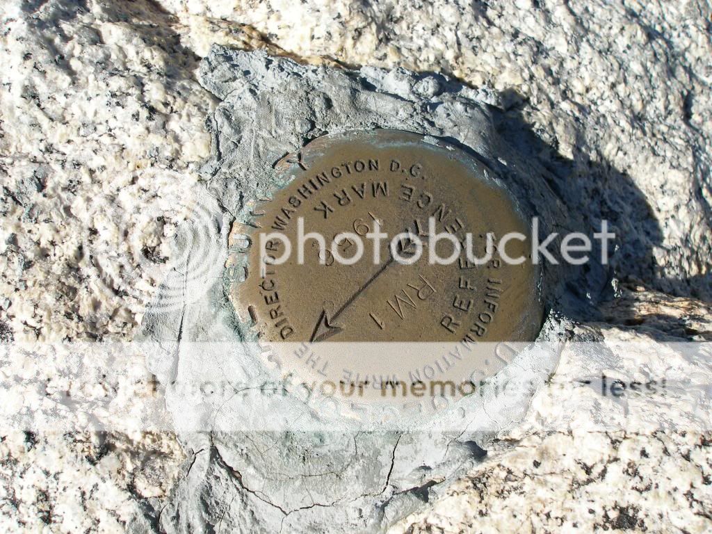
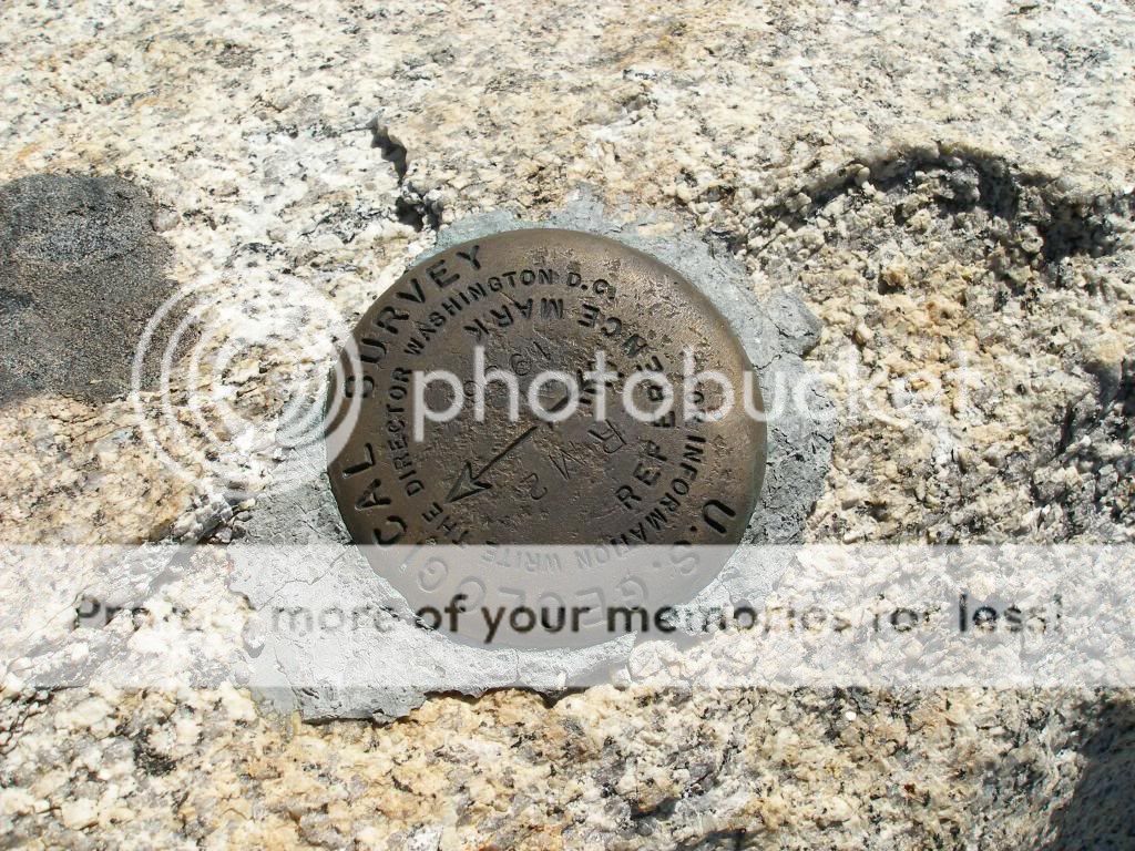
The marker on Pico Blanco is a triangulation station marker, so there should be one or two reference markers nearby. Did you see them? They are usually less than 50' from the triangulation station marker. Triangulation station markers are not very common, you see the regular benchmarks much more frequently.

For example, here are the triangulation station marker and reference markers on Mitchell Peak


On Florence Peak


And on Mt Whitney - Note that the reference markers are the older style without the arrow that points at the triangulation station marker


Here are the station marker and reference marker 2 on Alta peak; I need to go back and find reference marker 1


Last edited:
Yeah, I misspoke; it is indeed a triangulation station marker and not a mere elevation benchmark. I keep forgetting to look for the reference marks. I made the same mistake the last time I ran into a triangulation station marker on the Lost Coast:

IMG_5949_zps016d407a.jpg~original

NGS

Chalk it up to forgetfulness borne of general ignorance, and enjoying the views :o I remember reading up on it briefly a while back, but I don't remember how exactly the station markers were used in map-making and such (I mean, beyond the basic concept of triangulation/resection). The reference markers don't serve any actual function other than making finding the station marker easier, correct?

But yeah, I usually run into elevation benchmarks like this one near me on Black Mountain:

299389_10100396385177723_688178918_n_zpsb3b66742.jpg~original

USGS

ETA: What I want to know, is why most of the elevation markers I come across don't actually have any elevation marked on them... here's another by US Army Corps of Engineers on top of Chalk Mountain in Big Basin SP, and this one doesn't even have a location on it...:

IMG_5368_zps56e9bb25.jpg~original

USACE
 
Last edited:
Haha, good job employing shame in wresting performance out of him :) 18%, and at the end no less, is a bit of a wringer for sure. Good luck with the training :thumbup: Do you ride regularly, then?

Nothin' he wouldn't do to me, the swine.

I ride a bunch but I'm not a MAMIL. I've bounced about a bit with bikes and my current take uses one mah woman calls Poofy. I can see why too, but it's filling this niche great.

I was used to riding road bikes a bit down West. When I started spending a lot of time in Sussex that wasn't working out so well because I don't make the clear division between road + bike and off road + foot that I do down there.

That got me marginally interested in mountain bikes for a bit. There's not much in the way of mountains in Sussex though so I was losing a lot just to have a lazy capability to roll up hills easier. Meddled about with a few different combinations roosting last year at two, a mountain bike that effectively became a barrow for fishing stuff and a cheap hybrid that truth be told I bought because I found it beautiful not 'cos it was a great idea [2013 Whyte Portabello].

That was fun but still, each was master of nothing, yet simultaneously each a little too dug in to their respective strengths to be good general purpose machines.

Voilà, the emergence of Poofy. I built Poofy up from an old Dawes hybrid that was only £700 odd new. It's slant is more toward an early generation 26” hard everything mountain bike than a road bike Courier / Commuter that goes like the clappers, but you don't chicken out of the odd bump. And usefully it has a bunch of goodness that one usually finds on a tourer. Poofy now sports butterfly bars, and loaded up with luggage it's easy to see why she calls it that.

Enter bloke mentioned earlier. Stuff got more competitive when he kept taking his bike to the LBS to have work done that I think one should be able to do oneself. Told him so to, especially with the dig “and you're gonna be a father, watcha gonna do, send him round my house”. The fight has been on ever since. “You with whatever parts you like and your professional pit crew at the LBS vs me and whatever I cobble together”. It's been fun, and now I'm just rubbing it in mercilessly. I'd expect no less of him if the boot was on the other foot.

In short, I rocking ancient 9 speed technology with SRAM X7 shifters and a UN55 bottom bracket [that's like £12], with some old Shimano levers I'm fond of to V brakes and blah, and unless we get properly off road I can spank him into the weeds all day long. I can sit at 15-18 mph for hours on end. That doesn't sound too fantastic, but when you offset that against being able to sit at 30-35mph on some nice sections without trying and spinning like an egg whisk, yet still being able to take a bit of rough, I'm liking this a lot. And given advanced notice I can either pull it one way with some pretty fat nobbles or load up with some 26*1.5 slicks, that really seals it.

That 18% isn't so bad. I think that last mile actually bounces about between 15-18%. I'm calling it 18% all the way 'cos that's the way I practice for it. I've an 18% stretch just behind me that if I go up it 6* makes the mile. I figure the rests I get between climbs balances out against the climb proper not being 18% for all of that last mile.

On the actually event proper its quite important to be able to get to that hill intact and quickly. 27000 people rode the route on the last event. MAMILs on road bikes get to it first and have a clear shot. Mountain bikes make up the bulk of the herd, and although they should have a far easier time getting up that they are usually so w4nkered from the 50 miles they're walking. If you get caught in that you're screwed. The best part is that Beacon starts climbing just down the road from where matey has just bought The Hatchery for his woman, and he didn't know that. Now he does there aren't really any excuses.


There are other charity rides the Heart Foundation has up this end that are deceptively far far harder. I've walked most of The South Downs Way, in various chunks, and although it is certainly not smooth I wouldn't have pegged it as quite as painful as they do. I would have thought most places up north would be far harder. Seems not, and whilst a lot of it scores a 3/5 some of it 5/5 for hang tough. They can keep that particular randonee.

30 miles last night. Weed and vodka. Sprinkle of rain at the end and just a little squiffy by home time. Love it.
 
Doesn't look quite like this now, that's some nasty unwrapped foam bars for starters, and still on 1.95 City Jets. This was an early proof of concept run out to the airport. 30 mile loop.

Once I start to get to 50-60 miles even on that R2 saddle my rissole is not as comfy as I'd like so I call that a fair maximum for a day. I have zero motivation to start lubing up mah undercarriage whether they call it chamois cream or anything else.

DWN6g8cew320_B.jpg
 
Back
Top