The NEW Post Your Campsite/gear/knife/hiking/anything Outdoorsy Pic Thread!

Owen, these are they.

http://dumpt.com/img/files/e1jh1baqhoym54iaeyk8.jpg

http://dumpt.com/img/files/ifw1y8gtfaerp2n20l6h.jpg

http://dumpt.com/img/files/jybmlrr3tshk5hregy7j.jpg

http://dumpt.com/img/files/k2fgobz5k1dudi654hiz.jpg

http://dumpt.com/img/files/eg7046cx4fyg4c29d48p.jpg

http://dumpt.com/img/files/2mpbyrchks5pb5yooqel.jpg

http://dumpt.com/img/files/w2wtavvg1822dfmabva5.jpg

One can hold auditions any time. As much as it can be fun to get down a hole with a contestant, I can be a bit intolerant of taking others out into the sticks sometimes. In fact,
dgb019uyoyf06rbb5r70.jpg
 
True, true.
Thanks for the links. That works-I can see a small version of them. Nice reminder of days gone by:thumbup:
 
That's what I've been meaning to ask!
Love that pic. That was taken outdoors? What is it doing posted in this forum:confused:


One can hold auditions any time. As much as it can be fun to get down a hole with a contestant, I can be a bit intolerant of taking others out into the sticks sometimes. In fact,
dgb019uyoyf06rbb5r70.jpg
Quite tolerable, so far. Took to off-trail scrambling like a champ, too.
 
Guess while I'm at it, might as well post up a few waterfalls from the past couple weeks...and a lost bison:eek:
6yp5.jpg


High Falls, near Groveoak, AL.
tym1.jpg


High Falls.
v2r7.jpg


We got into a little snowstorm at Cloudland Canyon in GA.
72bl.jpg


Cherokee Falls.
m2yn.jpg


Hemlock Falls.
cfx2.jpg


Unnamed fall in Sitton's Gulch.
snfn.jpg


Unnamed fall in Sitton's Gulch.
36j1.jpg


Also introduced my new "sidekick"(maybe she'll never see this:rolleyes:) to Savage Gulf in TN.
Savage Falls.
50ao.jpg


Upper Greeter Falls.
pwum.jpg


Lower Greeter Falls.
bl6z.jpg


Unnamed off-trail falls.
cc6x.jpg


Boardtree Falls.
wftx.jpg
 
Russell - Looks like a great hike. This is the perfect time of year for it.

The marker on Pico Blanco is a triangulation station marker, so there should be one or two reference markers nearby. Did you see them? They are usually less than 50' from the triangulation station marker. Triangulation station markers are not very common, you see the regular benchmarks much more frequently.

For example, here are the triangulation station marker and reference markers on Mitchell Peak

I will give you guys a little background on the triangulation stations and why they are found on peaks - it's not because they were surveying the mountains, as some might assume.

The NGS (formerly USCGS, and now controlled by the NOAA) has been continually surveying and improving the accuracy of land surveys in the U.S. since the mid 19th century. Triangulation allowed surveyors to cover a wider area quicker. For national surveys, it is best to take the longest shots you possibly can. It is faster, and it increases accuracy. Since obstructions can limit visibility, it was easier for surveyors to climb to the highest peaks and survey to other high peaks, especially in mountainous terrain. With Modern equipment, state laws usually ask for surveys to have a closure better than 1:10,000 (meaning that for 10,000 linear feet in a survey, the angle of error should be less than 1 foot) - we can usually get between 20,000 and 200,000 with modern total stations, and with GPS it's usually between 100,000 and better than 1,000,000. Since their traverse shots were so long, the USGS surveys have had accuracy of more than 1,000,000 long before the advent of GPS.

In conventional surveying you spend a small amount of time setting up your stations so you can move on, but in the past it was often quicker to spend time developing an advantageous station to be accessible and accurate. Surveyors shot long distances by constructing towers, and it saved time building those towers and taking out 5 or 6 intermediate shots.

The reference markers are in place to help surveyors find the actual benchmark (they will often be covered by dirt and vegitation. We started using capped Iron pins, and just assume that on a return survey we will use reference marks (usually other stations in those cases, and not witness stations) to locate the approximate area, and clear the ground to find the actual stations. Also, people have a bad habit of vandalizing things, some people are even stealing them, and the weather can damage or destroy stations, especially over decades. With the two witness stations, it is easy to replace a marker that is missing. Witness stations are close enough to be accessible and within view on the ground of the primary station, but far enough away that a surveyor can get an accurate angle when shooting in to it. You would never want one closer than 10', even with modern equipment.

Some of the stations set during the 70s were traversed by helicopter, so surveyors didn't necessarily climb the highest peaks. Now, USGS uses photogrammetry (I could be saying that wrong) and known control to develop topo mapping. It isn't always as accurate, but for most uses it is accurate enough, and most importantly it's cheaper and quicker. Flight mapping uses a mix of aerial photos and designated survey targets to scale and align a topo map. It is very accurate, we set 6' markers that are visible from the air, and they point to known stations that are surveyed for horizontal coordinates and elevation. These large maps are usually accurate to within 1'. The USGS maps are usually off 15'-100'.

There are a lot of resources available about surveying, and the markers. Here are a few I found over the years, and have bookmarked on my CPU.

History of Survey Markers

History of Geodetic Surveys in the US

Buttermilk: The Oldest Surviving U.S. survey marker

The government publishes comprehensive documents on the location of benchmarks. Here in my state most are located near highways near drainage (not on peaks). I have charts and references that are listed by county, and since we use GPS a lot and our 2 types of GPS machines go 6 miles and 15 miles respectively, I have an excel file for the stations we use the most. However, there is a website that shows NGS stations overlaid on Google Maps

NGS Benchmark Viewer
 
Hola, is the move and the job going smoothly?

That's what I've been meaning to ask!
Love that pic. That was taken outdoors? What is it doing posted in this forum:confused:

Thanks guys, the move was arduous but the new place is pretty nice. I'm working on getting up to speed at the new job, lots to learn. Thankfully I'm starting to get my weekends back, been in dirt time withdrawal. Haven't had much time to post pics here, will work on remedying that soon.

Owen, glad to hear you have a partner in outdoor crime now :) Right on! :thumbup: And as always, love the pics! Love all the water!

A Justice, thanks for sharing your info and links. I'm definitely going to be reading em :thumbup:

Found a triangulation marker out on a hill in Point Reyes a couple trips back, only managed to find one reference marker... could not for the life of me locate the other... was probably buried in the scrub.
 
Been a month, so I guess I'll throw in some pics from the last four weeks.

-Here's another "High Falls" in AL, this one from a dayhike with my girlfriend in the Cheaha Wilderness.
qnzdp.jpg


-The next bunch is from Virgin Falls SNA, near Sparta, TN. My third trip there. To keep things interesting, this time I camped by the Caney Fork River, and hiked the Overlook Trail up to "Martha's Pretty Point"(neither of which I'd done before), plus played among the small falls and cascades down in the creekbed the trail parallels for the first couple of miles on the way in.

Big Laurel Falls
d81z.jpg


lw25.jpg


Sheep Cave Falls
lakyv.jpg


One of my trekking poles is somewhere at the top of that bottom tier. Lucky I didn't fall in there with it while climbing down that left side.
c4mk.jpg


Virgin Falls. Maybe my favorite waterfall.
5i7x.jpg


The river near where I camped.
7vwi7.jpg


OR Filament pullover. Weighs about the same as some of my cotton t-shirts, warm to ~40F so far(guess it'll be awhile before I get to see if it'll go lower!) and still comfy in the 60s. Now it's all the extra clothing I take for warm weather with cool nights. See my stick I had to cut to use in place of a trekking pole to support my tent? And no bug netting! Got swarmed at the TH, but the bugs weren't bad while hiking, and it went to 41F.
m4le.jpg


Osprey's new Exos 38, lidless with the "Flapjacket". My stuff is so compact now that I could probably use it for a week in moderate weather, if I ever got out for that long...
Pack weight is ridiculous now, too. I'm way past it being an issue(somewhere between inconsequential and unnoticeable), but it's so much fun to play with this stuff. I start laughing every time I weigh up my gear. This time it was ~12lbs for an overnight, and 3 of that was water that I didn't even need to carry.
6ec5.jpg


Martha's Pretty Point
qept.jpg


-Cheaha again. This is Cheaha Falls. I don't take many pics there any more, since I've been there dozens of times.
5gap.jpg


-These are from North Carolina's Shining Rock Wilderness.
Looking Glass(that rock face in the distance) from the Art Loeb trail.
r6ngo.jpg


The scenery was great sometimes, but the view from the trail often looked like this, too...not like those Western mountains!
2mr9.jpg


Think this is from Tennent Mountain, not sure.
eevp.jpg


Sunset from Shining Rock.
iikp.jpg


Ivestor Gap.
qm20l.jpg


Think this was while looping around Graveyard Ridge/Fields.
nz3bz.jpg


More new toys:
My girlfriend gave me a Four Dog Stove Bushcooker LT Mini Alcohol/Hexamine stove with titanium windscreen. Fantastic(girlfriend and stove), and 70g(just the stove!) after I cut down the pot supports. They're supposed to act as spare tent pegs..whatever-kind of silly, IMO.
8fnjl.jpg


Underground Quilts Flight Jacket 50F quilt. 72" length, Wide, full taper, snaps and drawstring at the foot instead of a sewn footbox.
Since I really didn't want anything else, my parents bought it from me before I could use it, then gave it to me as my birthday present.
My parents kind of rock!
d3ewj.jpg


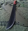
Got a new lightweight wood splitter to go with my saw come cool weather again. Mora Companion HD. It's quite visible...
fiyzj.jpg
 
ESEE Lite Machete with godspeed tac sheath
 

Attachments

  • ESEE Machete 2.jpg
    ESEE Machete 2.jpg
    92 KB · Views: 59
  • ESSE Machete 1.jpg
    ESSE Machete 1.jpg
    85.4 KB · Views: 51
Had my eye on a Fiskars X25 splitter for some time - finally put the cash on the barrelhead today:

rkeor.jpg
 
2014-06-02073238_zps3493ba0c.jpg
[/URL][/IMG]
_zps4zc4onlr.jpg
[/URL][/IMG]
2014-06-02230615_zpse6bd7bab.jpg
[/URL][/IMG]
2014-05-31052005_zps8b2731cc.jpg
[/URL][/IMG]
2014-06-01004633_zps150ebdc8.jpg
[/URL][/IMG]
20140531_195237-1_zpswtuygqjw.jpg
[/URL][/IMG]
Backpacking in Utah with the WILDMANH...
 
Back
Top